Avoid Unnecessary Travel, Do Not Drive Through Flood Waters
If you must travel, plan ahead, take the time to know the risk in your area.
Sunday 09 January 2022 | 08:51

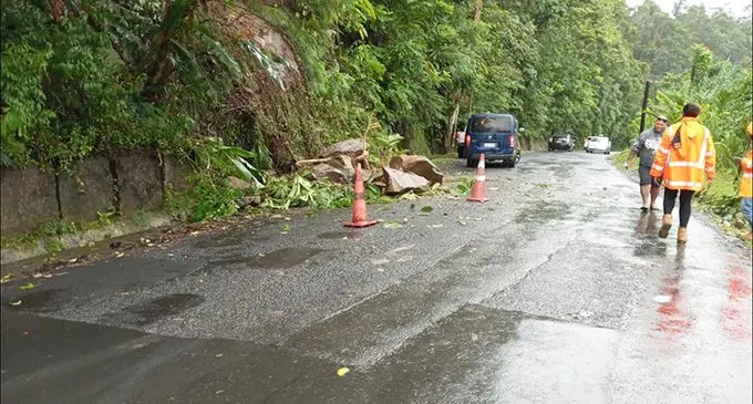
The landslide at Wailoku Road has been cleared. The road is now accessible. Please be on high alert for the possibility of rock falls, landslide and debris on the roadway. Slow down and drive to the conditions. Members of the public can contact the FRA on toll free number 5720 shall they have any queries.
As the heavy rain continues in most part of the country, there is a risk of further flooding.
Fiji Roads Authority (FRA) Chief Executive Officer Kamal Prasad is advising members of the public to remain vigilant and not to drive through flood waters.
- All Main Supply Routes (MSR) in the Central Division are open. The Unsealed MSR in the Eastern Division are open, however motorists are urged to drive to the conditions.
- Flood waters in the Western Division are closely being monitored with high tide at 1300 hours, we are expecting closures on some sections of Queens Road. Currently, 4x4 restrictions are imposed for Nadi Back Road, Sabeto Flats and Saweni Top (near University Fiji).
- Due to flooding Kings Road is closed at Yaladro flat and Tagitagi. 4x4 restrictions are imposed at Korovou flat (Tavua) and Rakiraki Bridge flat.
- All MSR in the Northern Division is accessible from Labasa Town towards Savusavu Town, Nabouwalu Town through Nabouwalu Road and Wainikoro Government Station towards Wainikoro Road (North of Labasa). MSR on Taveuni and Rabi are serviceable.
Related stories
“With several roads around the country flooded, making them impassable at this stage, please avoid unnecessary travel. If you must travel, plan ahead, take the time to know the risk in your area, be on high alert for flooding and the possibility of rock falls, landslide and debris on the roadway. Slow down and drive to the conditions,” “Mr Prasad said.
He said they were urging parents and guardians to please supervise their children, especially those that are living close to rivers and streams.
The FRA GIS dashboard link below shows the status of the road network.