Weather Update 0800 Hours: Storm Warning Remains In Force For Kadavu, Matuku, Moala And Totoya
The dangerous storm force winds are confined to Kadavu, Matuku, Totoya and Moala this morning, and will likely spread to Kabara, Fulaga and other nearby islands in the Lau group later today.
Sunday 29 December 2019 | 09:58
Warnings
A STORM WARNING REMAINS IN FORCE FOR KADAVU, MATUKU, MOALA AND TOTOYA.
A STRONG WIND WARNING IS NOW IN FORCE FOR YASAWA ISLANDS.
Related stories
A HEAVY RAIN WARNING REMAINS IN FORCE FOR THE FIJI GROUP.
A FLASH FLOOD WARNING REMAINS IN FORCE FOR LOW LYING AREAS, SMALL
STREAMS AND AREAS ADJACENT TO MAJOR RIVERS IN THE CENTRAL, NORTHERN
AND WESTERN DIVISION.
A FLOOD WARNING REMAINS IN FORCE FOR LOW LYING AREAS AND AREAS
DOWNSTREAM TO NAVOLAU STATION IN THE REWA RIVER.
A FLOOD ALERT REMAINS IN FORCE FOR LOW LYING AREAS AND AREAS:
DOWNSTREAM OF NAYAVU STATION IN THE WAINIBUKA RIVER,
DOWNSTREAM OF BA FSC STATION IN THE BA RIVER,
DOWNSTREAM OF NAIRUKURUKU STATION IN THE WAINIMALA RIVER.
Weather Situation:
To begin with, let's start with the list of warnings above. Missing is the Gale Warning.
The official gale warning issued by Fiji Met Service on its most recent cyclone warning reads as follows:
A GALE WARNING REMAINS IN FORCE FOR VANUA LEVU, TAVEUNI AND NEARBY
SMALLER ISLANDS, MAMANUCA GROUP, BEQA AND VATULELE, VITI LEVU AND
NEARBY SMALLER ISLANDS, LOMAIVITI AND THE REST OF LAU GROUP.
In reality, gales are confined to a much smaller region than this.
Those in the capital will have already noticed the significant decrease in wind speeds overnight.
Few if any stations who have actually reported at 6am have winds of gale force.
Best estimate is that gales are confined to the area within 150km of the centre on the north and east quadrants of the cyclone, and about 120km on the south and west quadrants.
The dangerous storm force winds are confined to Kadavu, Matuku, Totoya and Moala this morning, and will likely spread to Kabara, Fulaga and other nearby islands in the Lau group later today.
For Fiji:
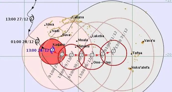
Category 2 Tropical Cyclone Sarai has meandered slowly eastwards overnight and was located about 100 km southeast of Vunisea Kadavu at 6am this morning.
Currently the cyclone is barely moving, perhaps east-northeast at about 5 kph.
The latest forecasts indicates the centre of TC Sarai will be located approximately 80 km southwest of Matuku at 6pm this evening and about 80km south-southeast of Matuku at 6am tomorrow morning.
Over Viti Levu winds have shifted west-northwesterly and eased somewhat, although winds are still blustery at times about the west.
In the capital winds are light - a result of the reversal of the prevailing east to southeast trade winds.
For now Suva is the warm and dry side of the island while Lautoka and Nadi are the wet and cool places.
As the cyclone drifts away winds will tend southwesterly over the western division, and ultimately southerly once the TC moves over eastern Lau and heads for Tonga later tomorrow and early on NYE.
Winds will stay northwest to northerly for now over the northern and eastern divisions where the circulation of TC Sarai is most influential at this time.
Gales and storms, along with bursts of heavy rain continue over Lomaiviti, central and southern islands of the Lau group, as well as Kadavu, and the hazards associated with TC Sarai are far from finished in Fiji.
Outlook for the next three days:
The weather is set to improve over the western half of the country from today through to New Years Eve, but only slowly. Washing day tomorrow for many as the sun peeps through. Most people on Viti Levu should be able to clear any debris and flood waters will have receded to manageable levels. Farmers should be happy, for a while at least, and water tanks should be full. A nice start to the new year on Wednesday with mostly sunny skies and pleasant trade winds.
Next Update 4 pm today.